Showing 297 items matching subdivision map
-
 Lorne Historical Society
Map - Subdivision Map, J Batten Lithos, Plan of West Lorne Loutitt Bay Allotments IV and V
... Subdivision Map...One of the early subdivision maps of Lorne.... Parade Lorne great-ocean-road Subdivision Map Map Plan of West ...One of the early subdivision maps of Lorne.Black and white printed map on cream paper. The map shows allotments from the Erskine River to the Grand Pacific with an inset of allotments between Smith and Otway Streets. Allotments have the owners names.. The sea baths, Cobb and Co stables , Mountjoys Hotel, the Church of England, the telegraph line to Geelong and the jetty are also marked.lorne, subdivisions, -
 Wodonga & District Historical Society Inc
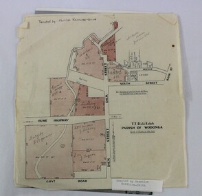
Map - Hamilton-Smith Collection Subdivision Map of Wodonga
... Hamilton-Smith Collection Subdivision Map of Wodonga ...A printed map of a Wodonga subdivision with hand written...-Smith Collection Subdivision Map of Wodonga Map A printed map ...The Hamilton-Smith collection was donated by the children of Grace Mary Hamilton-Smith nee Ellwood (1911-2004) and John Hamilton-Smith (1909-1984) who settled in Wodonga in the 1940s. The Ellwood family had lived in north-east Victoria since the late 1800s. Grace’s mother, Rosina Ellwood nee Smale, was the first teacher at Baranduda in 1888, and a foundation member of the C.W.A. Rosina and her husband Mark retired to Wodonga in 1934. Grace and John married at St. David’s Church, Albury in 1941. John was a grazier, and actively involved in Agricultural Societies. The collection contains significant items which reflect the local history of Wodonga, including handmade needlework, books, photographs, a wedding dress, maps, and material relating to the world wars. This item has well documented provenance and a known owner. It forms part of a significant and representative historical collection which reflects the local history of Wodonga. It contributes to our understanding of social and family life in early twentieth century Wodonga, as well as providing interpretative capacity for themes including local history and social history. A printed map of a Wodonga subdivision with hand written annotations On top proper right corner: "Donated by Merrilyn Hamilton-Smith". map, subdivision, wodonga, local history, maps, hamilton-smith, hamilton-smith collection -
Lorne Historical Society
Map, F W Niven Lithos, The Mountjoy Lorne Estate, 1889
... Subdivision map... was that of the Mountjoys. The subdivision map was printed in 1889... was that of the Mountjoys. The subdivision map was printed in 1889 Lorne Subdivision ...In 1888 a company was formed to acquire and subdivide the land of the Mountjoy Brothers. The land totaled 197 acres and included Erskine House. The land colored red was that of the Mountjoys. The subdivision map was printed in 1889A paper map of the Mountjoy Estate Lorne , showing allotments, with their owners, and naming land use. It has four black and white line drawings , Erskine House, Mountain View’s, the Rapids, Erskine House sea view and Erskine Falls. The map is largely black and white with red and blue colouring. The map is mstuck to brown paper. lorne, subdivision map, erskine house, mountjoy brothers, -
Ringwood and District Historical Society
Envelope, Nunawading, Ringwood, East Ringwood Land Subdivision Sales, and Grid Map of Melbourne
... Nunawading, Ringwood, East Ringwood Land Subdivision Sales... Subdivision Sales - Grid map of Melbourne..., East Ringwood Land Subdivision Sales, and Grid Map of Melbourne ...Land Subdivision Sales - Nunawading; Land Subdivision Sales - East Ringwood; Land Subdivision Sales - Ringwood; Land Subdivision Sales - Grid map of Melbourne -
 Whittlesea Historical Society Inc.
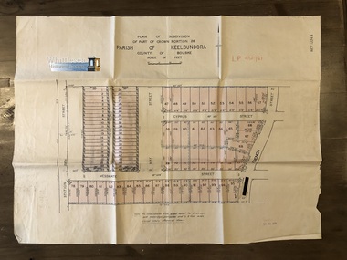
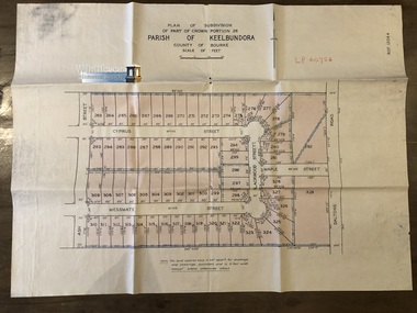
Map, Garlick and Stewart, Engineers and Surveyors, Plan of Subdivision of Part of Crown Portion 26, Parish of Keelbundora, County of Bourke, c. 1956
... subdivision map...Map shows subdivision of blocks numbered 1 - 95, sizes... Whittlesea melbourne Map Plan of Subdivision of Part of Crown Portion ...Subdivision of Part of Crown Portion 26, Lalor, Vic. Station Street, Messmate Street, May Street, Cyprus Street and French Street recorded on the map.Map shows subdivision of blocks numbered 1 - 95, sizes of the blocks, and names of the surrounding streets. Map 1 of 20 in green folder.Garlick and Stewart, Engineers and Surveyors, Melbourne. LP 40751. Sealed 11 Jul 1956map, subdivision map, station street, messmate street, may street, cyprus street, french street, lalor -
 Whittlesea Historical Society Inc.
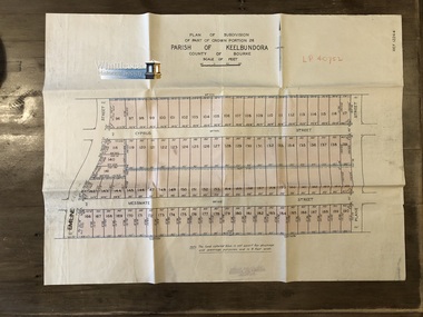
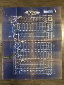
Map, Garlick and Stewart, Engineers and Surveyors, Plan of Subdivision of Part of Crown Portion 26, Parish of Keelbundora, County of Bourke, c. 1956
... subdivision map...Map shows subdivision of blocks numbered 96 - 190, sizes... Whittlesea melbourne Map Plan of Subdivision of Part of Crown Portion ...Subdivision of Part of Crown Portion 26, Lalor, Vic. French Street, Messmate Street, Cyprus Street and Plane Street recorded on the map.Map shows subdivision of blocks numbered 96 - 190, sizes of the blocks, and names of the surrounding streets. Map 2 of 20 in green folder.Garlick and Stewart, Engineers and Surveyors, Melbourne. LP 40752. Not dated, assumed 11 Jul 1956.map, subdivision map, messmate street, cyprus street, french street, lalor, plane street, lalor map -
 Whittlesea Historical Society Inc.
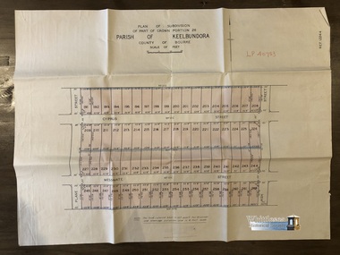
Map, Garlick and Stewart, Engineers and Surveyors, Plan of Subdivision of Part of Crown Portion 26, Parish of Keelbundora, County of Bourke, c. 1956
... subdivision map...Map shows subdivision of blocks numbered 191 - 262, sizes... Whittlesea melbourne Map Plan of Subdivision of Part of Crown Portion ...Subdivision of Part of Crown Portion 26, Lalor, Vic. Messmate Street, Cyprus Street, Ash Street and Plane Street recorded on the map.Map shows subdivision of blocks numbered 191 - 262, sizes of the blocks, and names of the surrounding streets. Map 3 of 20 in green folder.Garlick and Stewart, Engineers and Surveyors, Melbourne. LP 40753. Not dated, assumed 11 Jul 1956.map, subdivision map, messmate street, cyprus street, lalor, plane street, lalor map, ash street -
 Whittlesea Historical Society Inc.
Map, Garlick and Stewart, Engineers and Surveyors, Plan of Subdivision of Part of Crown Portion 26, Parish of Keelbundora, County of Bourke, c. 1956
... subdivision map...Map shows subdivision of blocks numbered 263 - 329, sizes... Whittlesea melbourne Map Plan of Subdivision of Part of Crown Portion ...Subdivision of Part of Crown Portion 26, Lalor, Vic. Messmate Street, Cyprus Street, Ash Street, Maple Street and Daltons Road recorded on the map.Map shows subdivision of blocks numbered 263 - 329, sizes of the blocks, and names of the surrounding streets. Map 4 of 20 in green folder.Garlick and Stewart, Engineers and Surveyors, Melbourne. LP 40754. Not dated, assumed 11 Jul 1956.map, subdivision map, messmate street, cyprus street, lalor, plane street, lalor map, ash street -
 Federation University Historical Collection
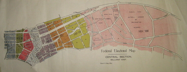
Plan - Plans, Tulloch & King, Federal Electoral Map Subdivision of Ballarat, c1901
... Federal Electoral Map Subdivision of Ballarat... Plan Federal Electoral Map Subdivision of Ballarat May ...It is thought that these are the first federal electorial plans for the Subdivision of Ballarat. The first member of Ballarat was Alfred Deakin.May of the Federal subdivision of Ballarat, with each section depicted in a different colour. The plans include Lake Wendouree, Central Ballarat subdivision; Soldiers Hill subdivision; Ballarat East subdivision, and Central Section Ballarat East, including the Ballarat East Botanic Garden .ballarat, federation, alfred deakin, elections, plan, electoral division, electoral map, polling -
 City of Kingston
Pamphlet - Colour, S. M. Reynolds, Estate Agent, Moorabbin Shire Hall Estate Second Section, c. 1930
... Handwritten in grey pencil on subdivision map below... Handwritten in grey pencil on subdivision map below subdivision 63: £4 ...Sales plan for land in the suburb of Moorabbin, bounded by South Road and Highbury Street, including Prince Street, Charming Street, Thomas Avenue and Keith Road.The developing urban area of Moorabbin within the City of Kingston. This land sale pamphlet illustrates the subdivision of land within the municipality and the changing demographic of the district as new houses are constructed close to infrastructure.Colour pamphlet advertising for private sale the Moorabbin Shire Hall Estate, Moorabbin. Incorporates a map of the estate bordered by South Road and Highbury Street, including Prince Street, Charming Street, Keith Road and Thomas Avenue.Handwritten in grey pencil on subdivision map below subdivision 63: £4 Handwritten in grey pencil on subdivision map below subdivision 66: 4 Handwritten in grey pencil on subdivision map below subdivision 80: 3. Handwritten in grey pencil on subdivision map below subdivision 81: 4 Handwritten in grey pencil on subdivision map below subdivision 83: 2 Handwritten in grey pencil on subdivision map below subdivision 96: £3 Handwritten in grey pencil on subdivision map below subdivision 97: 3 Handwritten in grey pencil on subdivision map to the left of subdivision 102: 3 Handwritten in grey pencil on subdivision map on the corner of Thomas Avenue and Highbury Street: vertical line next to a square with a cross in it.land sales, estate, moorabbin -
 Greensborough Historical Society
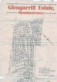
Map, Glengarriff Estate Montmorency, 1938c
... Colour photocopy of subdivision map, on two A3 sheets ... Colour photocopy of subdivision map, on two A3 sheets Estate ...Estate Agent's plan of Glengarriff Estate, Montmorency, covering LPs 11334 and 11451. Bordered by Sherbourne Avenue, Calrossie Avenue, Montmorency Station and Price AvenueColour photocopy of subdivision map, on two A3 sheets glengarriff estate montmorency, sherbourne avenue montmorency, calrossie avenue montmorency, price avenue montmorency, montmorency station -
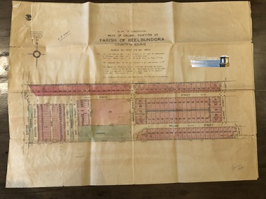
 Whittlesea Historical Society Inc.
Map, Plan of Subdivision of Part of Crown Section 25, at Thomastown, Parish of Keelbundora, County of Bourke
... subdivision map... Whittlesea melbourne Map Plan of Subdivision of Part of Crown Section ...Plan of Subdivision of Part of Crown Section 25, at Thomastown, Parish of Keelbundora, County of Bourke Epping Road, Mount View Road, Tramoo St, Hurtle St, Arndell St, Travers St, Westall St, Chappell St, and Pleasant Road, recorded on the map.Blue sheet. Aged sticky tape on map. Map 6 of 20 in green folder. Shows subdivision of blocks numbered 1 - 340, sizes of the blocks, and names of the surrounding streets. LP 13050. Undated.map, subdivision map, thomastown map, thomastown, epping road, mount view road, tramoo street, hurtle street, arndell street, travers street, westall street, chappell street, pleasant road -
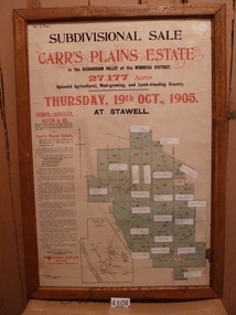 Stawell Historical Society Inc
Memorabilia - Realia, 1905
... with Subdivision Map... Poster with Subdivision Map Stawell ...Carr’s Plains Estate Subdivision Sale Poster with Subdivision Mapstawell -
 Whittlesea Historical Society Inc.
Map, Gulliver & Sim, Licensed Surveyors, Plan of Subdivision of Part of Crown Portion 26, Parish of Keelbundora, County of Bourke, c. 1953
... subdivision map... along the fold lines. Map 1. shows subdivision of blocks... Whittlesea melbourne Map Plan of Subdivision of Part of Crown Portion ...Subdivision of Part of Crown Portion 26, Lalor, Vic. Map 1: Station St, David St, William St, May St, French St and Dalton Road. Map 2: David St, William St, Munro St, Jean St, Lorne St, Plane St, Ash St and Dalton Road. Messmate Street, Cyprus Street, Ash Street, Maple Street and Daltons Road recorded on the map.Two sheets, attached. The maps are fragile and have tears along the fold lines. Map 1. shows subdivision of blocks numbered 19 - 124, sizes of the blocks, and names of the surrounding streets. Map 2. shows subdivision of blocks numbered 19 - 124, sizes of the blocks, and names of the surrounding streets. Map 5 of 20 in green folder. Map 1. LP 29211. Map 2. LP 29212. Both maps, Sealed 13 May 1953. Gulliver & Sim, Licensed Surveyors, 15 Lorrean Avenue, East Brighton. S6. Tel. X54780.map, subdivision map, lalor, plane street, lalor map, ash street, david street, william street, may street, french street, dalton road -
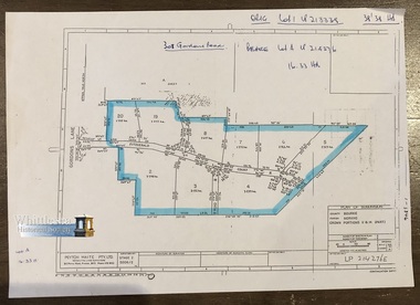 Whittlesea Historical Society Inc.
Map, Peyton Waite Pty. Ltd, Consulting Land Surveyors, Plan of Subdivision, County Bourke, Parish Morang, Crown Portions 11 & 14 (Part)
... subdivision map... Whittlesea melbourne Map Plan of Subdivision, County Bourke, Parish ...Morang is now as Mernda. Plan of Subdivision, County Bourke, Parish Morang, Crown Portions 11 & 14 (Part). Gordons Lane and Fitzgerald Court, recorded on the map.A4 page. Map 7 of 20 in green folder. Shows subdivision of Crown Portions 11 &14 (part) blocks numbered 2 - 8 and 19 - 20, sizes of the blocks, and names of the surrounding streets.LP 214276E Undated. Peyton Waite Pty. Ltd, Consulting Land Surveyors, 353 Plenty Road, Preston. Vic.map, subdivision map, morang, mernda, gordons road, fitzgerald court, morang map, mernda map, plan of subdivision -
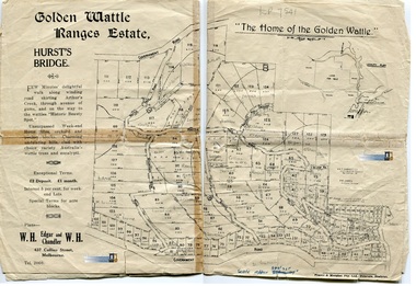 Whittlesea Historical Society Inc.
Map, Peyton Waite Pty. Ltd, Consulting Land Surveyors, Land for Sale, Golden Wattle Ranges Estate, Hurst's Bridge, Vic
... subdivision map... Hurstbridge), Vic. map subdivision map hurst's bridge hurstbridge ...Land for Sale in Hurst's Bridge (now Hurstbridge), Vic.Undated, 1 sheet. Map 8 of 20 in green folder. Shows land for sale, sizes of the blocks, and names of the surrounding streets, Hurstbridge Rialway Station, Cool Stores, Wine Cafe 7 Billiard Saloon, Shops and Hall. The map is fragile and held together with sticky tape. It was scanned in 2 sections along the fold line and then joined to form 1 image. Previous inventory notes map is dated 23/2/62.A. K. T. Sambell C. F., Civil & Hydroolic Engineer, 421 Collins Street. P. M. James, Licensed Surveyor, Victoria St. Plans - W. H. Edgar and W. H. Chandler, 437 Collins St, Melbourne.map, subdivision map, hurst's bridge, hurstbridge, hurstbridge railway station, hurstbridge cool stores, hurstbridge billiard saloon -
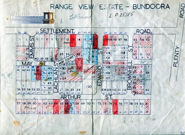 Whittlesea Historical Society Inc.
Map, Range View Estate - Bundoora
... subdivision map... St, Brownhill St and Arthur St. map subdivision map range ...Range View Estate - Bundoora, Settlement Road near Plenty Road, including Elms St, May St, May Court, Lachlan St, Edward St, Brownhill St and Arthur St.Undated, A4 sheet. Map 9 of 20 in green folder. Shows block number and names of the surrounding streets names, one section bounded by Settlement Road.L.P 25185map, subdivision map, range view estate, bundoora, settlement road bundoora, plenty road bundoora, may st, lachlan st, brownhill st, arthur st, elms st -
 City of Kingston
Pamphlet - Colour, W. H. Wood Estate Agent, Subdivisional Land Auction Barker's Estate Cheltenham, 1919
... Handwritten in grey pencil on the subdivision map: a series... the sale price. Handwritten in grey pencil on the subdivision map ...Sales plan for land in the suburb of Cheltenham, along Barker StreetThe developing urban area of Cheltenham within the City of Kingston. This land sale pamphlet illustrates the subdivision of land within the municipality and the changing demographic of the district as new houses are constructed.Colour pamphlet advertising subdivisional land auction of Barker's estate, on Barker Street Cheltenham.Handwritten in grey pencil on the subdivision map: a series of numbers on each block possibly indicating the sale price. Handwritten in grey pencil on the subdivision map: Roy- joined to subdivision 6 Handwritten in grey pencil on the subdivision map: x on the border between subdivision 17 and 16, and again on the border between subdivision 12 and 11.cheltenham, land sales, estate -
 City of Kingston
Pamphlet - Colour, Arthur Tuckett & Son, Auctioneers and Subdivisional Specialists, Attractive subdivisional auction of Station Estate, Moorabbin, 1923
... on subdivision map: x [on majority of properties marked on the map...] Handwritten in red pencil on subdivision map: x [on majority ...Sales plan for land in the suburb of Moorabbin, bounded by Railway Crescent, South Road, Jasper Road and Pattersons Road.The developing urban area of Moorabbin within the City of Kingston. This land sale pamphlet illustrates the subdivision of land within the municipality and the changing demographic of the district as new houses are constructed.Colour pamphlet advertising an auction of the Station Estate Moorabbin. Incorporates details of the shopping facilities, proximity to the railway line, variety of schools and churches in the area, and a sales plan for home sites and shop fronts. Incorporates a map of the estate bordered by Pattersons Road, Japer Road, South Road and Railway Crescent. Handwritten in grey pencil top right front page: Station Estate / late [indecipherable] Handwritten in red pencil on subdivision map: x [on majority of properties marked on the map] Handwritten in grey pencil on subdivision map: additional subdivisions drawn in and large lines drawn across the mapmoorabbin, land sales, estate -
 Kiewa Valley Historical Society
Paper Sheet - Shire of Bright Plans
... typed writing and subdivision maps of the Kiewa Valley Planning... yellow (or orange). Black typed writing and subdivision maps ...Oblong sheet of paper - bright yellow (or orange). Black typed writing and subdivision maps of the Kiewa Valley Planning Scheme in the Shire of Bright. Circa 1980s2 pages of maps and scriptshire of bright, maps, kiewa valley -
 City of Kingston
Pamphlet - Colour, H. R. Hill & Co, Walker's Estate, Cheltenham for sale by public auction, c. 1923
... Handwritten in black pen on subdivision map: 'x' written... Cheltenham estate Handwritten in black pen on subdivision map: 'x ...Sales plan for land in the suburb of Cheltenham, encompassing both sides of Walker Grove, a section of Centre Dandenong Rd and Axelton St. The developing urban area of Cheltenham within the City of Kingston. This land sale pamphlet illustrates the subdivision of land within the municipality and the changing demographic of the district as new houses are constructed.Black and white pamphlet advertising for private sale the Station Entrance Estate, Highett. Incorporates a map of the estate bordered by Wickham Road, Railway Parade, Highett Road and Point Nepean Road.Handwritten in black pen on subdivision map: 'x' written on subdivisions 2, 3, 8-11, 15-17, 19. Potentially indicating that these properties did not sell at auction. Handwritten in black pen on subdivision map: assumed sale price on subdivisions 1, 4-7, 12-14, 18, 20-31. land sales, cheltenham, estate -
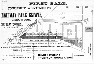 Ringwood and District Historical Society
Flyer, Subdivision advertisement - Railway Park Estate, Ringwood, Victoria - circa 1887
... Subdivision map includes Pitt Street and Main Ferntree... of sale and location map. Subdivision map includes Pitt Street ...Photocopy of advertisement for auction sale of township allotments in Railway Park Estate, Ringwood, on Saturday 30th April (1887?), with terms of sale and location map.Subdivision map includes Pitt Street and Main Ferntree Gully Road (later Bedford Road). (Agents) Greig & Murray, Thompson Moore & Son, Auctioneers. -
 Falls Creek Historical Society
Document - Information Bulletin April 1961
... Committee. Information included is the release of a new subdivision... subdivision map, establishment of a Ski Rescue Service ...Bob Hymans Collection Bob (Herman) Hymans (a former Pilot in the Royal Netherlands Navy) was born in Bloemendaal, Holland on 30th September 1922. During World War II he fought against the Japanese in the Dutch East Indies (now Indonesia) and was imprisoned in Changi and on the Burma Railway. After gaining qualifications as a Ski Instructor, Bob arrived in Falls Creek in July 1950. Working as an Instructor and Supervisor at Bogong Lodge, Bob decided his future was in accommodation. He was successful in negotiating an indenture for land from the State Electricity Commission (SEC). It took Bob two years to build his Grand Coeur Chalet but, tragically, it was burned down in August 1961. Bob also built the first Chairlift in Australia. This was a single chairlift and the structure was built from wooden electricity poles. He was constantly full of new ideas and proposals for the village. Bob Hymans die on 7th July 2007. This Collection of documents and letters tells the story of Bob's endeavours to develop Falls Creek into the ski village it is today.This letter is significant because it documents developments made or endorsed by the Falls Creek Tourist Area Management Committee.An information bulletin published by the Management Committee. Information included is the release of a new subdivision map, establishment of a Ski Rescue Service and notification that Bob Hymans' would not be in operation for the coming season,falls creek tourist area management committee, preparations for winter season 1961 -
 City of Kingston
Pamphlet - Colour, Stillwell and Co, The Hill Estate, Highett, 1917
... Handwritten in grey pencil on subdivision map next... in grey pencil on subdivision map next to subdivisions 91, 92, 93 ...Sales plan for land in the suburb of Highett, bounded by Point Nepean Road and including Sandford Street, Turner Road, Alfred Street and Peace Street.The developing urban area of Highett within the City of Kingston. This land sale pamphlet illustrates the subdivision of land within the municipality and the changing demographic of the district as new houses are constructed close to infrastructure.Colour pamphlet advertising for sale at auction The Hill Estate, Highett. Incorporates a map of the estate bordered by Point Nepean Road and including Sandford Street, Turner Road, Alfred Street and Peace Street.Handwritten in grey pencil on subdivision map next to subdivisions 91, 92, 93, 106, 107 and 108: x Handwritten in grey pencil on back cover: The / Hill Estate / Highettland sales, estate, highett -
 City of Kingston
Pamphlet - Colour, Ozone Hill Estate, Cheltenham, 1923
... Handwritten in blue ink on the subdivision map: 'Sold... on the subdivision map: 'Sold' is written on subdivisions 1-4, 8, 11, 13, 16 ...Sales plan for land in the suburb of Cheltenham, along both sides of Victori Avenue, off Weatherall Road.The developing urban area of Cheltenham within the City of Kingston. This land sale pamphlet illustrates the subdivision of land within the municipality and the changing demographic of the district as new houses are constructed.Colour pamphlet advertising for sale the Ozone Hill Estate, Cheltenham. Incorporates a map of the estate on either side of Victor Avenue, off Weatherall Road. Handwritten in blue ink on the subdivision map: 'Sold' is written on subdivisions 1-4, 8, 11, 13, 16-26, 28, 29, 33, 39-41 Handwritten in blue ink on the subdivision map: 'House being erected' is written on subdivisions 22 and 33. Handwrittten in grey pencil adjacent to subdivisions 21 and 22: Tennis / Courts / being / constructed / here Handwritten in grey pencil at bottom of page: Revised to 30/1/24 Handwritten in grey pencil on subdivision map: assumed land sale price is recorded on subdivisions 5-9, 9-10, 12, 14-15, 27, 30-32, 34-38. land sales, cheltenham, estate -
 City of Kingston
Pamphlet - Colour, Stillwell and Co, The Hill Estate Highett Great Subdivisional Auction Sale, 1917
... Handwritten in blue pencil on subdivision map: [tick] [on majority... sale pamphlet illustrates the subdivision of land within ...Sales plan for land in the suburb of Highett, bounded by Point Nepean Road and incorporating Sandford Street, Turner Road, Alfred Street, Peace Street and Tennyson Street. .The developing urban area of Highett within the City of Kingston. This land sale pamphlet illustrates the subdivision of land within the municipality and the changing demographic of the district as new houses are constructed.Colour pamphlet advertising subdivisional auction sale of the Hill Estate Highett. Incorporates a map of the estate bordered by Point Nepean Road and encompassing Sandford Street, Turner Road, Alfred Street, Peace Street and Tennyson St. Handwritten in grey pencil on reverse: Hill Street / Jamieson Handwritten in blue pencil on reverse: The Hill Estate Handwritten in blue pencil on subdivision map: [tick] [on majority of properties marked on map]highett, land sales, estate -
 City of Moorabbin Historical Society (Operating the Box Cottage Museum)
Plan - Grandview Estate
... Hand drawn map of subdivision ... Estate Plan Hand drawn map of subdivision Grandview Estate ...The train line from the city to Frankston was electrified in 1922 which intensified the sale in the municipality of Moorabbin, particularly land which was in the vicinity of the railway stations.The train line from the city to Frankston was electrified in 1922 which intensified the sale in the municipality of Moorabbin, particularly land which was in the vicinity of the railway stations. The Grandview Estate was auctioned on Saturday 10 November 1922.Example of the progress of the Municipality of MoorabbinHand drawn map of subdivision Grandview Estate, Bentleighcentre road, evelyn street (now wilson street), lily street, bentleigh, realestate, auction -
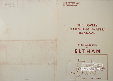 Eltham District Historical Society Inc
Photograph, For Private Sale in Subdivisions; The Lovely "Laughing Water" Paddock on the Yarra River at Eltham
... Collins Street, Melbourne Location plan and subdivision map... Collins Street, Melbourne Location plan and subdivision map ...Private sale of the "Laughing Water" paddock in subdivision; 5 river frontages with weatherboard villa on Lot 8; 6 woodland blocks of 5 and 6 acres. Sole Agent: Edward Haughton, 379 Collins Street, Melbourne Location plan and subdivision mapA3 colour photographic print from digital image of sales brochure and A4 reproduction of price listlaughing waters, edward haughton, real estate agent, eltham -
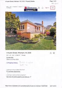 Whitehorse Historical Society Inc.
Document - Various including maps, titles, posters, Land ownership of 4 Austin Street, Mitcham, 1873 - 2019
... by Martin and Shirley Gleeson 1956 and sold in 2019. Subdivision... by Martin and Shirley Gleeson 1956 and sold in 2019. Subdivision map ...Ownership history of 4 Austin Street, Mitcham.Ownership history of 4 Austin Street, Mitcham between 1873 to 2019, including the plan of the Mellorton Estate, Mitcham (1923), showing some lots priced at one hundred and forty-five pounds and the Charlesworth Estate ((1913). The Austin Street house was purchased by Martin and Shirley Gleeson 1956 and sold in 2019. Subdivision map of area south of Burnett Street to Harrison Street. non-fictionOwnership history of 4 Austin Street, Mitcham.drake real estate, charlesworth estate mitcham, mellorton estate mitcham, austin street mitcham no4, ainger frank -
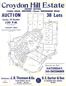 Ringwood and District Historical Society
Flyer, Land Auction Sale Advertisement, Croydon Hill Estate, Croydon, Victoria - 1959
... Subdivision map includes Richardson Road, Yarra Road..., November 26, 1959. Subdivision map includes Richardson Road, Yarra ...Single sided land auction sale advertisement for 38 residential allotments - Croydon Hill Estate (Second Section) Yarra Road, Croydon - corner Whitehorse Road. Auction Saturday, 5th December, and corresponding newspaper advertisement - Ringwood Mail, Thursday, November 26, 1959.Subdivision map includes Richardson Road, Yarra Road, Whitehorse Road, Alice Street, Hull Street (later Mulawa Stret). Auctioneers in Conjunction: J.B. Thomson & Co., Station Entrance, Box Hill, (Telephone) WX 1862, WX 7356, and at Nunawading, WU 1968, WU 3452, and C.E. Carter & Son, 126 Whitehorse Road, Ringwood. WU 6024.